Bexhill Cycle Route consultation
Overview
East Sussex County Council (ESCC) is developing a range of schemes across the county that aim to create safer, more sustainable communities, and align with the Government’s commitment to encouraging more active travel.
We are currently looking to take forward a new cycling and walking route in Bexhill which will extend and improve the current network in the town.
The proposed route was identified through work carried out for ESCC’s Local Cycling and Walking Implementation Plan and is funded by the Government’s Local Growth Fund (LGF) which aims to introduce measures to improve conditions for those walking, cycling, and using public transport.
Consideration of recent Department for Transport Guidance
In partnership with ESCC, East Sussex Highways has developed a preliminary design for a route from Collington to Worsham.
We are very much aware of the recent Department for Transport (DfT) guidance on cycle infrastructure design (LTN 1/20) published in July 2020. It is recognised that this local transport note has proposed a step-change in the approach to the planning and development of cycle infrastructure and this will be a tool that will be used for developing future cycle infrastructure projects.
At the time of the publication of the new guidance the route that we are now consulting on had been substantially developed. We therefore recognise that the proposals may not fully achieve all of the core design principles set out in LTN1/20. However, the design process has been subject to rigorous assessments that seek to ensure that cyclists have the highest level of provision possible, whilst also considering other road users.
The Collington to Worsham route runs between the existing National Cycle Network Route 2 on the seafront via Collington Station to Bexhill Enterprise Park in Worsham. It is proposed that the alignment in the Worsham area will use the existing shared cycle/pedestrian path on Mount View Street and connect to the rest of the route via cycling facilities currently under development by an external developer in the North Bexhill Residential Development area. Discussions are also underway with third parties to ensure suitable cycling and walking facilities can be achieved through a proposed mixed-use development off Down Road, with interim measures in place whilst this is being progressed.
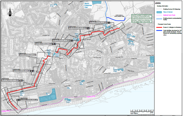
Please click here to see a large version of the proposed route.
The proposed route largely consists of on-road facilities to allow cyclists to travel in either direction from Collington to Worsham. The route connects to the existing National Cycle Network Route 2 (NCN2) at the seafront and links to Collington Train Station, King Offa Primary Academy, Bexhill Leisure Centre, Bexhill Hospital and Bexhill Enterprise Park. A map illustrating the proposed route can be viewed above.
To make it easier to review the proposed route and design, the route has been divided into 8 drawings running in a linear fashion from south to north (Seafront towards Worsham).
Click Here for Drawing 1 – Richmond Avenue to Terminus Avenue
The route starts from the existing National Cycle Network (NCN2), which runs along the coast of Bexhill, at the junction of Richmond Avenue/South Cliff. The route continues along Richmond Avenue and Westcourt Drive, then turns right into Terminus Avenue. Cylists will travel on the carriageway in both directions. New double yellow line parking restrictions, no waiting ‘at any time’, are proposed in Richmond Avenue to improve visibility.
Click Here for Drawing 2 – Terminus Avenue
The route will run along Terminus Avenue and enter the junction of Terminus Road and Colebrooke Road. Parking restrictions in Terminus Avenue near this junction will be extended westwards to improve safety for cyclists. Cyclists will travel on the carriageway in both directions. On B2098 Collington Avenue and Terminus Road, cyclists will be directed to position themselves in the existing right turn pockets to wait for a break in traffic (if required) before turning into Terminus Road or Colebrooke Road.
Click Here for Drawing 3 – Colebrooke Road and Downlands Avenue
The route continues along the carriageway of Colebrooke Road and Downlands Avenue. Parking restrictions at the southern end of Colebrooke Road are proposed to be extended to improve safety for cyclists.
Click Here for Drawing 4 – Arthur Road to Down Road, crossing at A259 Little Common Road
Cyclists travelling north will continue along Arthur Road before leaving the carriageway and joining a proposed 3.0m wide shared footpath. New double yellow line parking restrictions, no waiting ‘at any time’, are proposed around the junction with Piltdown Close and in Arthur Road to improve visibility.
The existing Puffin crossing on the A259 Little Common Road will be upgraded to a Toucan crossing allowing cyclists and pedestrians to cross together without the need for cyclists to dismount.
The route will cross the A259 Little Common Road and continue on a proposed 3.0m shared footway within the green area between A259 and Down Road.
Cyclists will cross Down Road at the existing uncontrolled crossing point onto the footway in front of the King Offa Primary Academy. There is a local pinch point at the southwest corner of the school where cyclists will have to manoeuvre with care before continuing along this proposed shared use footway.
The shared route will end at the access road to the car park and cyclists will join the access road carriageway leading to an interim route in the Bexhill Leisure Centre area.
The southbound journey towards to the seafront is simply a reverse of these movements.
The route continues along the access road next to King Offa Primary Academy northwards and turns right to the public footpath. Cyclists will be required to dismount to use the public footpath before reaching the subway under Combe Valley Way. The access road and the public footway around Bexhill Leisure Centre is an interim measure, subject to a future mixed-use development being completed. East Sussex County Council is liaising with Rother District Council and other third parties to develop suitable cycle/pedestrian facilities in this location.
The existing subway under the Combe Valley Way and footway alongside London Road will be converted to shared use for cyclists and pedestrians. The route then leads to Hillside Road. Cyclists will leave the shared footpath and join the carriageway at the existing raised junction of London Road/Hillside Road.
Cyclists heading north will remain on the carriageway on Hillside Road and turn right onto a footpath at the end of Hillside Road leading to Barrack Road. This footpath will be widened to a minimum of 3.0m and converted to shared use. Dropped kerbs will be provided at the southern end of Barrack Road for cyclists to re-join the carriageway.
Southbound journeys towards to the seafront will be a reverse of these movements.
Click Here for Drawing 6 – Barrack Road to Chantry Avenue
Cyclists will join the carriageway at the end of Barrack Road and remain on the carriageway, turning into Silvester Road.
At the northern end of Silvester Road, cyclists will turn right on the footpath towards Hollier’s Hill. It is proposed to widen the footpath to a minimum of 3.0m for shared use although there will be a localised pinch point around a mature tree.
Cyclists will remain on the footways in Hollier’s Hill which will be widened to a minimum of 3.0m before turning right onto Chantry Avenue. A new traffic island will be installed on Hollier’s Hill to help pedestrians and cyclists to cross the road. New double yellow line parking restrictions, no waiting ‘at any time’, are proposed on Hollier’s Hill to improve visibility and provide clearance for the new traffic island.
Southbound journeys towards the seafront will be a reverse of these movements.
Click Here for Drawing 7 – Chantry Avenue to Wychurst Gardens
At Chantry Avenue, cyclists heading north will re-join the carriageway. The route will remain on the carriageway along both Chantry Avenue and Wychurst Garden in both directions.
Click Here for Drawing 8 – Chatres and The Glades
The route will continue along Chatres and The Glades and remain on the carriageway. At the eastern end of The Glades, cyclists will leave the carriageway and use a converted and widened shared footway to reach a proposed Toucan crossing at Westwood Road. The existing traffic island at Wrestwood Road will be removed and the new Toucan crossing will be installed to allow cyclists and pedestrians to cross together without the need for cyclists to dismount.
After crossing Wrestwood Road it is proposed that cyclists will use cycling facilities within a new residential development and then utilise existing cycling/pedestrian facilities towards Worsham.
Why your views matter
We want to hear your views on the proposals and whether you support the changes or have any reason for them not being installed. Subject to the feedback received, we propose to implement the route around March 2023.
The proposals for the Collington to Worsham route are shown in the plans.
If you use assistive technology (such as a screen reader) or need a version of these documents in a different format, or you have problems accessing the documents generally, please email: customer@eastsussexhighways.com and let us know what you need and what assistance we can provide you to allow you to participate fully in this consultation process.
Please take the time to look at these proposals and tell us your views by completing the survey. Please click the link below to provide your feedback. We welcome any comments you may have.
We will also be happy to answer any questions you have. Please contact us by email customer@eastsussexhighways.com or telephone 0345 60 80 193.
The consultation period runs from 25 November to 16 December 2021. All comments need to be received by the 16 December 2021.
East Sussex Highways takes data protection seriously. For further information place see the Privacy Notices in the below link.
https://www.eastsussexhighways.com/privacy-notice-esh
Thank you for your interest in this consultation and for taking the time to look at the proposals.
Areas
- Hastings
Audiences
- Anybody with an interest
- Businesses
- Community groups or organisations
- Faith groups or organisations
- Public sector groups or organisations
- Residents of East Sussex
- Residents panel
- Voluntary groups or organisations
Interests
- Planning
Share
Share on Twitter Share on Facebook