Eastbourne Cycle Routes - Stone Cross
Overview
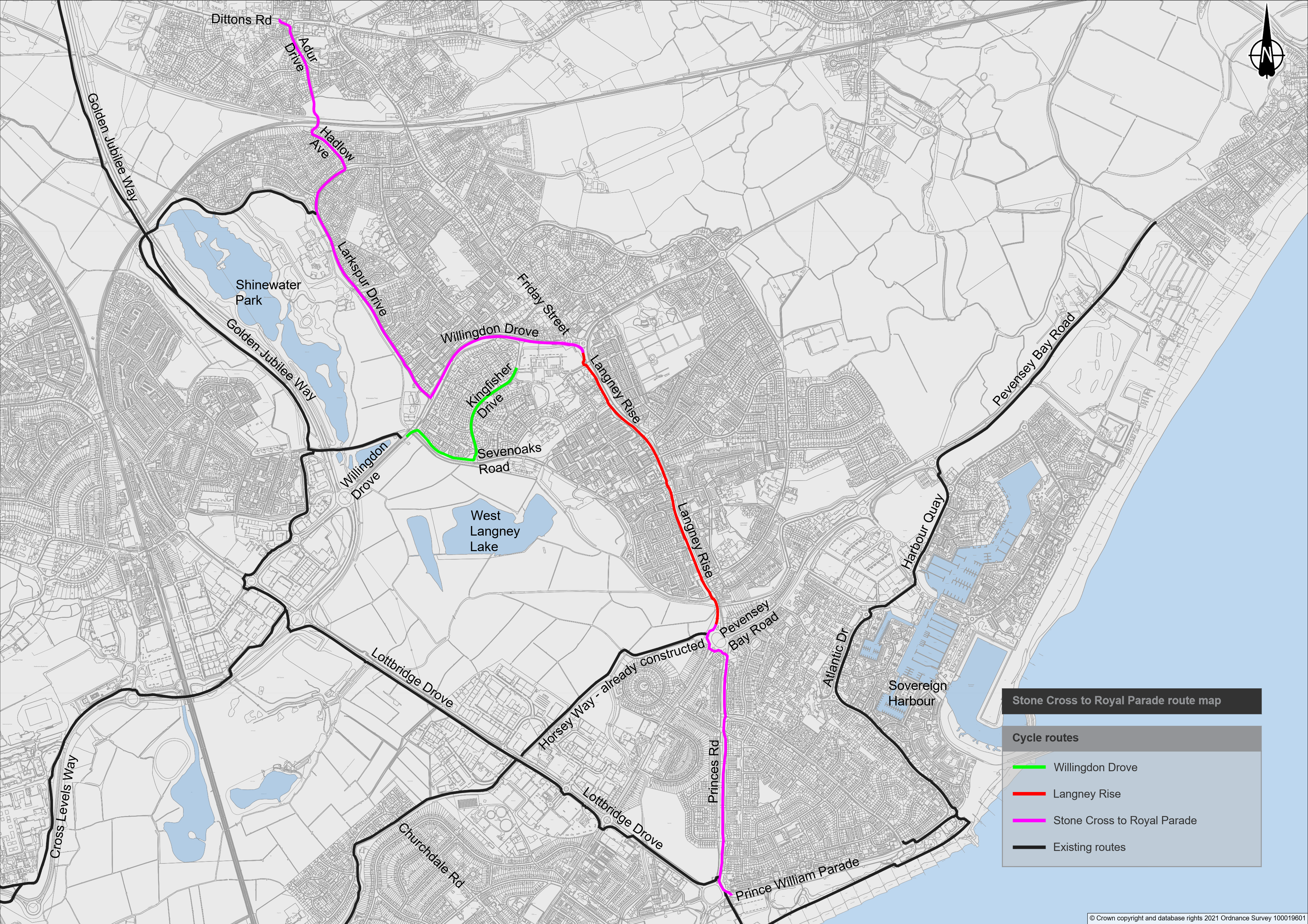
The proposed route consists of largely off-road shared facilities to allow cyclists to travel in either direction from Stone Cross, via Langney (adopting the Langney Rise cycle route) to the seafront. Access is provided to an off-road route on Dittons Road to Polegate, as well as the Horsey Way Cycle Route and the National Cycle Route 21. A map illustrating the proposed route can be viewed here.
To make it easier to review the proposed route and design, the route has been divided into 32 drawings running in a linear fashion from north to south (Stone Cross towards the seafront). The Stone Cross to Royal Parade cycle route is divided into two sections, which are connected by the Langney Rise Cycle Route.
Section 1 – Dittons Road to Langney Rise
Click Here for Drawing 1 – Dittons Road/Townsend Road – Prior to the start of the route, a 30mph gateway is proposed to the west of Townsend Road which will comprise of signs and an on-road roundel with red coloured surface. The existing shared footway facility on the northern side of Dittons Road provides the connection to the new Stone Cross to Royal Parade Cycle Route.
Click Here for Drawing 2 – Dittons Road/Adur Drive/St Michaels Close Roundabout – The route crosses Dittons Road on the western arm of the roundabout using a new parallel zebra crossing. On the southern side of Dittons Road the footway will be widened to 4 metres to provide a shared facility for pedestrians and cyclists. The route follows Adur Drive on the southern arm of Dittons Roundabout, where a new raised table and access ramps allows cyclists to enter and exit the carriageway, whilst slowing down the traffic.
Click Here for Drawings 3 to 5 – Adur Drive/Tillingham Way/Adur Park – Cycle symbols denote the route along the carriageway in both directions of this section of Adur Drive, specifically at conflict points such as the junctions. The Adur Drive/Tillingham Way junction will be raised, and access ramps installed with the existing raised table across Adur Drive to be incorporated. At the entrance to Adur Park, the existing guard railing will be removed and a new cycle “Sustrans Gate” (example shown below) will be provided. This will allow cyclists, mobility chairs and people with pushchairs to pass, but inhibit the passage of motorbikes. The route continues through Adur Park along the existing paved path which will be widened to 4 metres and converted to shared use.
![]()
Click Here for Drawings 6 to 7 – Adur Park/Hadlow Avenue – To the south of the rail bridge the existing guard railing will be removed and a new cycle “Sustrans Gate” will be provided. Where the turning head joins the path into Adur Park, “no waiting at any time” restrictions will be marked on the road to improve cyclist movements in and out of the Park. The route continues down Hadlow Avenue where cyclists will share the carriageway with other vehicles. Cycle symbols denote the new route in both directions, specifically at conflict points such as the junctions.
Click Here for Drawing 8 – Hadlow Avenue/Larkspur Drive – Travelling southbound, cyclists manoeuvre onto the footway on the west side of the junction of Hadlow Avenue, which has been narrowed to reduce vehicle speeds, and a right-turn pocket provided to aid movement and provide a semi-protected waiting area. The route then crosses Larkspur Drive where a new 2.5-metre-deep refuge island will be installed, and new lengths of “no waiting at any time” restrictions will be marked on either side of the road. Hatched markings will separate the traffic flows approaching the refuge island from both directions, extending to the junctions with Carisbrooke Close and Rotherfield Avenue. Continuing along the southern side of Larkspur Drive, the existing paved footway and verge will be converted to a shared use path.
Click Here for Drawing 8A – Larkspur Drive/Carisbrooke Close – Whilst not part of the route, a new right turn lane will be provided for Carisbrooke Close due to the proposed refuge island and hatched markings on Larkspur Drive.
Click Here for Drawings 9 to 10 - Larkspur Drive (Rotherfield Avenue to Sandown Close) – The Rotherfield Avenue southern corner radii will be tightened, and the footway extended to provide an enhanced pedestrian crossing location outside Meadows Nursery School. The existing priority operation traffic calming just north of the junction with Sandown Close is to be removed so that a new raised parallel zebra crossing can be installed. This will require a tree to be trimmed back on the western side of of the crossing, so that visibility is not blocked by branches. On the western side of the road the existing segregated cycle route will be converted to a shared use facility, with the central line to be removed. Furthermore, a Copenhagen style junction (example below) will be installed across the Causeway School entrance to provide priority to pedestrians and cyclists.
Click Here for Drawing 11 to 12 – Larkspur Drive (Sandown Road to Honeysuckle Close) – The route will then utilise the existing shared footway facility on the western side of Larkspur Drive. The existing guard railing just south of the Causeway School bus stop will be removed to provide more room for pedestrians and cyclists to share the footway. A Copenhagen style junction will be installed across the Shinewater Park entrance, which will provide priority to pedestrians and cyclists. Cyclists will cross to the other side of Larkspur Drive using a new raised parallel zebra crossing which will be installed between the junctions with Shinewater Park and Honeysuckle Close.
Click Here for Drawings 13 to 16 – Larkspur Drive (Honeysuckle Close to Willingdon Drove) – The route continues along the eastern footway of Larkspur Drive that will be widened to 3.5 metres to the mini roundabout with Willingdon Drove. The junctions with Honeysuckle Close, Briar Place, Foxglove Road and Erica Close will all be narrowed to reduce vehicle speeds and Copenhagen style crossing facilities will be incorporated to provide priority to pedestrians and cyclists. Existing parking bays between Honeysuckle Close and Briar Place will be removed to provide room for the new shared path (vehicles will be able to park on the carriageway).
Between Foxglove Road and Erica Close, the bus stop will be moved back where the footway has been widened. At the Larkspur Drive/Willingdon Drove roundabout cyclists join a new two-way cycle track that continues along the northern side of Willingdon Drove. A strip of verge will be added to provide some segregation between cyclists using the track and vehicles on Willingdon Drove.
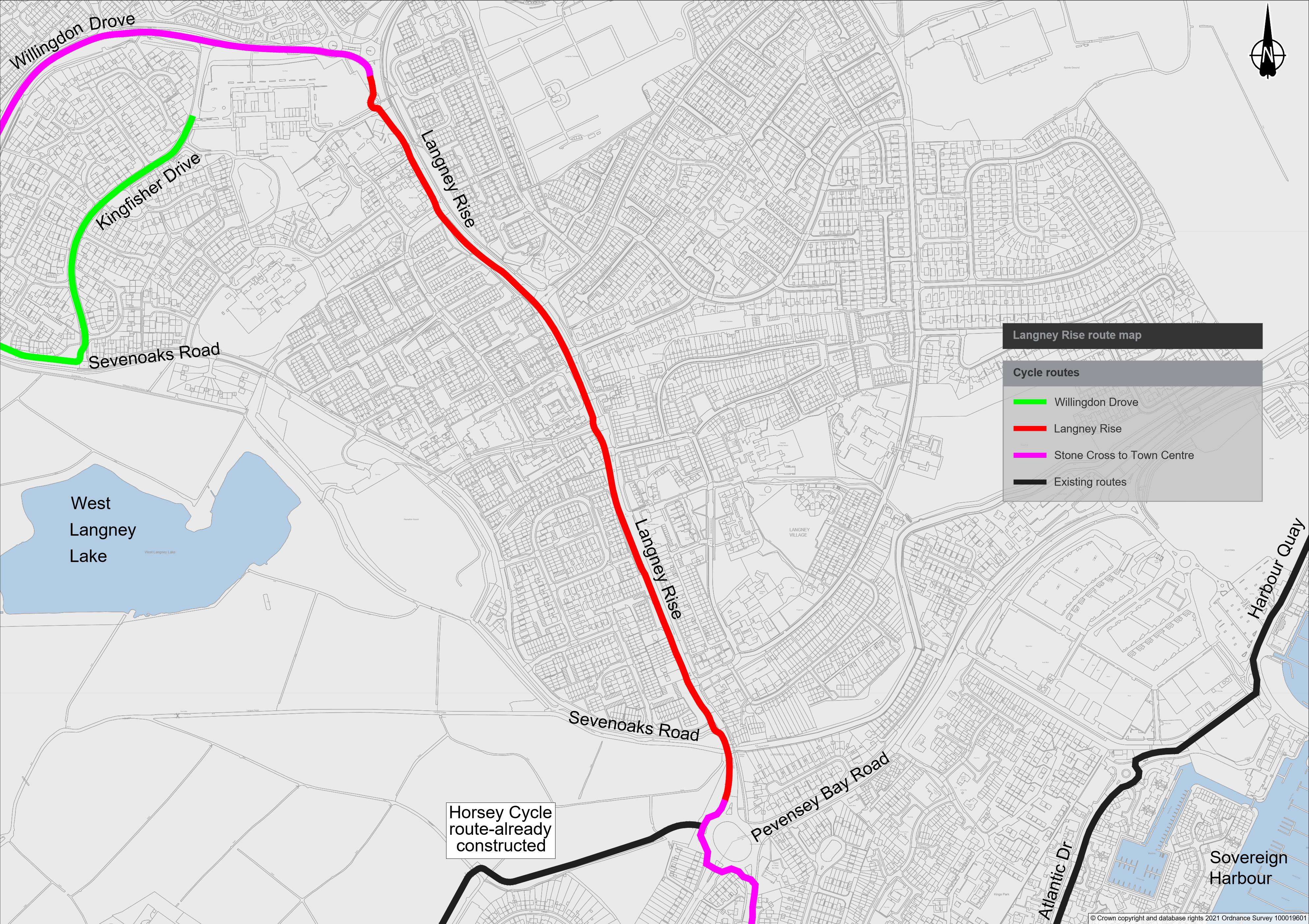
Click Here for Drawings 17 to 21A – Willingdon Drove/Langney Rise – The northern side of Willingdon Drove will be widened and resurfaced to create a two-way cycle track up to the mini roundabout with Milfoil Drive. Some existing trees and shrubs will be cut back to allow a width that varies between 2.5 metres and 3 metres for the cycle track. No pedestrian provision has been provided along this section of Willingdon Drove as there are more viable alternative routes.
On the western arm of the mini roundabout with Milfoil Drive, a new toucan crossing will be provided to provide a safe cycle crossing facility. Having crossed over, cyclists continue along the southern side of Willingdon Drove where a 3.5 metre two-way shared footway leads to a new parallel zebra crossing at the junction with Kingfisher Drive. The crossing will be set back 20 metres from the junction to allow storage of vehicles to prevent blocking of Willingdon Drove.
Cyclists join a new 3.5-metre-wide shared footway that leads to the Willingdon Drove/Friday Street roundabout, resulting in the need to cut back some trees and shrubs in the verge that borders Langney Shopping centre car park. From here, the route continues along the existing shared footway, past the double roundabout and approximately 35 metres down Langney Road to the bus stop, where the Langney Rise cycle route begins. Click here to view the Langney Rise cycle route
Section 2 – Langney Rise to Prince William Parade
Click Here for Drawings 22 to 23 – Langney Roundabout – Section 2 of the route connects at the southern end of the Langney Rise Cycle Route, on the west side of Langney Roundabout which is where and the Horsey Way Cycle Route to Lottbridge Drove. The footway running south to the pedestrian crossing on St Anthony’s Avenue will be widened to a 4.5 metre shared facility. The crossings on both St Anthony’s Avenue and Princes Road will be upgraded to Toucan crossings to allow pedestrians and cyclists to cross together, and the exits on both arms will be narrowed to provide shorter crossing distances. Both routes will also see the removal of existing guard railing within the central islands to reduce conflict. Having crossed both arms of the roundabout, cyclists join the footway on the eastern side of Princes Road.
Click Here for Drawings 24 to 31 – Princes Road - The existing paved footway on the eastern side of Princes Road will be widened to 4 metres and a new shared footway facility will be provided within the verge where the existing path begins behind the Ramsay Way southbound bus stop. The route continues down the full length of Princes Road on the eastern side, crossing Ramsay Way and Beatty Road where both junctions will be realigned to reduce vehicle speeds through the corner radii. Parallel zebra crossings are also proposed here to aid cyclist movement by providing them priority. From the midpoint of Princes Road to Beatty Road, where there is currently no footway, a new 4-metre-wide shared footway will be installed.
The two service road junctions between Ramsay Way and Beatty Road will have Copenhagen style entry treatment to provide priority to pedestrians and cyclists, with the northern junction also realigned to reduce vehicle speeds through the corner radii. A new short 2 metre section of footway to connect the footway on the north side of Beatty Road will also be installed.
The existing uncontrolled crossing across Princes Road, to the immediate north of the western service road and Middleton Drive junction, will also be upgraded with the provision of new kerbing and tactile paving.
Where street trees fall within the extent of the proposed path, these will be relocated or replaced within the adjacent grass verge area. Current electrical cabinets opposite the junction with Wallis Road will be relocated.
Click Here for Drawings 32 – Prince William Parade - At the approach to Sovereign Roundabout, cyclists can use the existing Toucan crossing to access the National Cycle Route 21. Cyclists heading to the seafront can continue along the existing shared footway on the east side of the roundabout to Prince William Parade, where a new toucan crossing (set back 20 metres from the junction entry) will provide a safe cycle and pedestrian crossing facility to the end of the Stone Cross to Royal Parade Cycle Route.
Click here to go to the homepage for the Eastbourne Cycle Routes.
Why your views matter
We would like to seek your views on the proposed design and route of the Stone Cross Cycle Route.
Areas
- Eastbourne
Audiences
- Businesses
- Community groups or organisations
- Voluntary groups or organisations
- Public sector groups or organisations
Interests
- Road and pavement repairs
- Road safety
- Traffic Regulation Orders
- Public Transport
Share
Share on Twitter Share on Facebook